

The National Weather Service flash flood risk map updated Thursday morning, July 31, 2025 shows increased probability of flooding. (Courtesy of NWS)
Rainfall rates may exceed 2 inches per hour, posing a flash flood risk in low-lying and poorly drained areas
A series of rainstorms rolled through the region Thursday, prompting the National Weather Service to expand a flood watch across much of eastern Pennsylvania — including all of Montgomery and Bucks counties — as the area braces for more heavy downpours and possible flash flooding overnight.
The watch remains in effect until 6 a.m. Friday, covering counties from Berks to Philadelphia, and most of New Jersey. The NWS warned that a warm and humid air mass ahead of a cold front will fuel potentially severe storms capable of dumping 2 to 4 inches of rain across the region, with isolated areas seeing more than 6 inches.
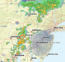 A screenshot from the National Weather Service Station KDIX in Philadelphia from 12:13 p.m. Thursday, July 31, 2025. (Courtesy of the National Weather Service)
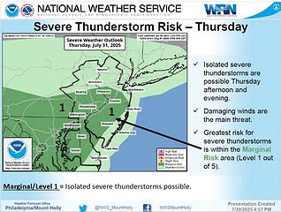 The National Weather Service updated map showing severe thunderstorm risks for Thursday, July 31, 2025. (Courtesy of NWS)
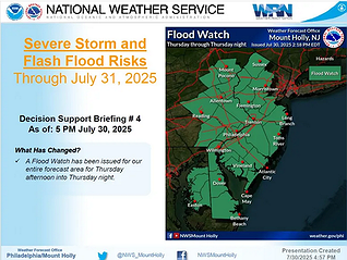 All of the region served by the Mount Holly N.J. office of the National Weather Service is at risk for severe weather Thursday, July 31, 2025. (Courtesy of NWS)
Rainfall rates may exceed 2 inches per hour, posing a flash flood risk in low-lying and poorly drained areas.
Thursday afternoon storms moving in from the west brought dark skies, humid air and short bursts of heavy rain. Conditions are expected to worsen into the evening, with a 90% chance of rain and possible thunderstorms overnight. Thursday’s high reached 83 degrees in Lansdale, with a forecast low of 65 by nightfall.
Friday’s outlook remains unsettled, with showers and storms possible before 8 a.m. and mostly cloudy skies throughout the day. The high is expected to be around 74, with a 60% chance of rain during the day and a 30% chance overnight.
However, the region should see relief just in time for the weekend. Forecasts call for sunshine and comfortable temperatures in the low 80s on both Saturday and Sunday.


